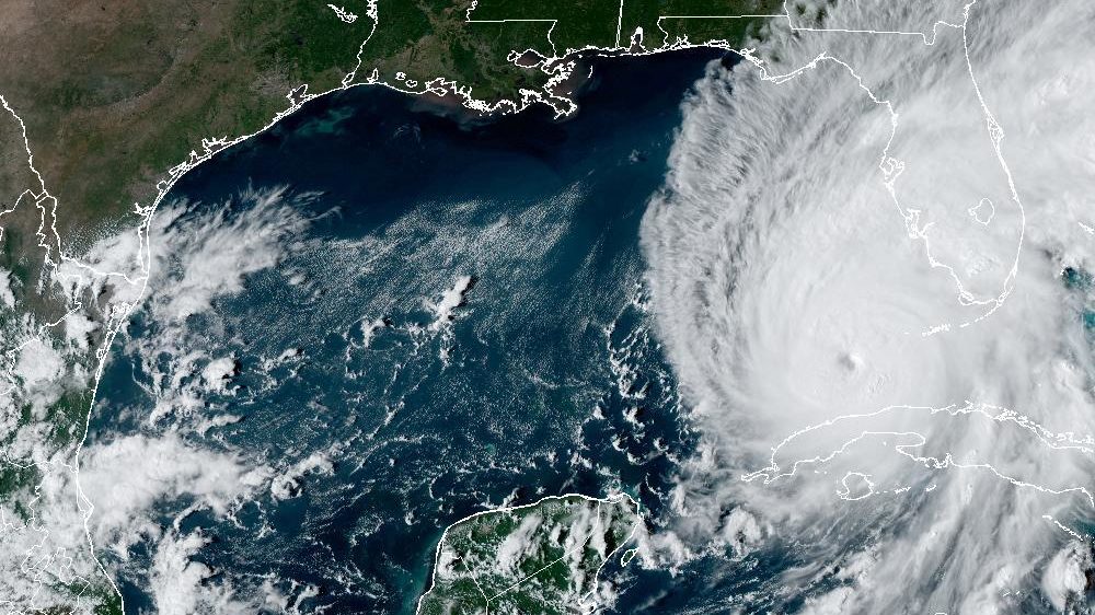
Hurricane Ian Satellite View [National Weather Service/National Hurricane Center]
By Bryan Boggiano
Hurricane Ian is a fast-evolving situation, with threats to South Florida and Broward County becoming more likely.
Ahead of the storm’s approach, businesses and Broward County Public Schools announced closures Tuesday to prepare for potential impacts.
The Latest
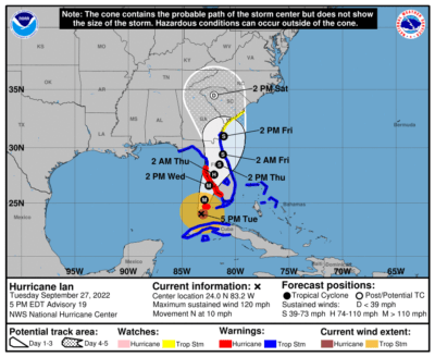
As of the 5 p.m. advisory from the National Hurricane Center, Hurricane Ian has maximum sustained winds of 120 miles per hour, and it is moving north at 10 miles per hour.
Ian is located about 230 miles south of Sarasota.
Ian will continue moving slightly east of due north over the next 24 to 36 hours. It is forecast to make landfall anywhere from near Fort Myers to Tampa late Wednesday as a Category 4 Hurricane.
The storm will slow as it moves across the state before exiting Florida Friday.
A tropical storm warning is in effect for Broward County, meaning tropical storm conditions are possible over the next 36 hours.
Ian presented forecasters with uncertainty, with the NHC originally pinpointing a possible landfall from Tampa Bay through the Panhandle.
Over the past 24 to 48 hours, global models such as the American GFS and the European ECMWF trended back east, putting anywhere from Fort Myers to Tampa in the potential landfall zone.
Ian also appears to be undergoing an eyewall replacement cycle. When this happens, storms briefly weaken but grow in size, meaning that their wind field expands, and the threat of life-threatening storm surges rises.
Potential Impacts
Even though Broward County is not in the NHC’s cone of concern, impacts from Hurricane Ian are still likely.
The cone represents where the center of a storm will most likely be located, but because of Ian’s size, flooding rains, gusty winds, and isolated tornadoes will be present beyond the 5-day cone.
Further deviations from the storm’s current path in any direction are also still possible, which will affect potential impacts.
According to the NHC, the chance of tropical storm force winds is 65 percent in Broward County. These winds could arrive as early as Wednesday morning.
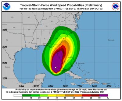
Hurricane Ian tropical storm wind probabilities [NWS/NHC]
An additional 4 to 6 inches of rain is possible through the week as Ian exits the state, with isolated amounts of 10 inches. This can lead to urban and flash flooding.
These floodwaters could contain hazardous materials, live power lines, and even wild animals.
Since Southeast Florida will be in the eastern quadrant of a landfalling hurricane, brief, isolated tornadoes are possible. These tornadoes can come with little to no warning and hamper emergency plans.
The Storm Prediction Center placed Southeast Florida in a level 2 out of 5, or slight risk, of experiencing an isolated tornado through Wednesday.
A tornado watch remains in effect until 5 a.m. Wednesday.
Even relatively weak storms or those that do not directly hit can cause significant effects.
In June, rain from Potential Tropical Cyclone One displaced residents from their apartments after the storm caused severe water damage.
Resiliency Basics
In an August interview, Lynne Martzall, Communications and Marketing director, stated that despite the uncertainty that comes with hurricane season and individual storms, it is important for residents to remain prepared.
“Even with the best prediction tools, it’s still impossible to know exactly when, where, and at what strength a hurricane or tropical storm will strike. The forecast can change at any time,” she said.
She also recommended that residents have enough food and water per person and pets to last at least three days. fill up their vehicles’ gas tanks, have extra cash, and store enough batteries and chargers for flashlights, cellphones, and radios.
Martzall also referred residents over to city pages on self and pet readiness for more information.
After the storm, Martzall stressed that residents should stay away from downed wires and call 911 if they suspect a gas leak.
In the event of power outages, she emphasized important points related to generator safety.
Martzall stated that residents should not use portable generators inside homes, garages, or sheds or near openings to homes, windows, or vents.
To receive up-to-date information from the city, she recommended texting AlertCS to 888-777.
Send Your News to Coral Springs #1 Award-Winning News Site Here. Don’t miss reading Margate Talk, Parkland Talk, and Tamarac Talk.
Author Profile

Related
 NewsJanuary 1, 2024BEST OF 2023: Inspiring Fitness Journey Earns Resident National Recognition
 NewsNovember 20, 2023Charter School Alum Works Toward Equity For Black Veterans
 NewsNovember 16, 2023Coral Springs Joins Regional Climate Effort, Commits to Bold Action Plan for Environmental Resilience
 NewsNovember 8, 2023Meet Dr. Juliana Forero: Leading Coral Springs Museum to New Heights with Inclusivity
