

By Bryan Boggiano
A hurricane in November? It is possible.
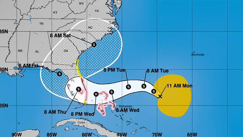
As Subtropical Storm Nicole heads toward Florida, the National Hurricane Center issued hurricane and storm surge watches for much of southeastern and east-central Florida on Monday morning.

As of the 10 a.m. advisory, Subtropical Storm Nicole has maximum sustained winds of 45 miles per hour and is moving northwest at 9 miles per hour. It is 495 miles east of the Northwestern Bahamas.
Nicole could be a Category 1 Hurricane at landfall late Wednesday or Early Thursday along southeastern or east-central Florida.
 "
"
Ahead of Nicole’s arrival, a Hurricane Watch extends from Hallandale Beach up to the Brevard/Volusia County Line. This includes all of Broward County.
This means hurricane conditions, sustained winds, or gusts up to 74 miles per hour are possible within the next 48 hours. Tropical-storm-force winds are possible, too.
A Storm Surge Watch is also in effect for much of eastern Florida, including coastal Broward County. Water could rise between two and four feet above normal tide levels, leading to coastal flooding.
Tropical-storm-force winds could arrive by early Wednesday, although the NHC states the most likely arrival time is late Wednesday afternoon. Rainfall amounts of two to four inches are forecast, with isolated amounts of six inches possible.
Due to the storm’s forecast impacts, the City of Coral Springs recommended residents and business owners to review their hurricane readiness plans.
>>> https://t.co/W86FCn3MUX pic.twitter.com/RgVrFx2eUq
— Coral Springs, FL (@CoralSpringsFL) November 7, 2022
Nicole will continue moving northwest through midday Tuesday. Then, it will move more westward and west-southwestward as high-pressure forms to its north.
Around this time, it is forecast to become fully tropical. Currently, the strongest winds and most convection are farther away from the center. The storm is expected to consolidate, but it will remain broad.
By midday Wednesday, it is forecast to become a hurricane.
Landfall is forecast early Thursday, possibly as a Category 1 Hurricane. From there, it is forecast to turn gradually to the northwest, followed by a turn to the north and northeast through Friday.
Where Nicole makes, landfall could mean significant differences in impacts.
[National Hurricane Center]
The storm’s structure is forecast to be lopsided to the north and east, where strong winds and heavy rain are forecast. The south side will have far less convection.
The area will have stronger and longer-lasting effects if Nicole tracks closer to southern Palm Beach County or extreme northern Broward County. That would mean increased wind damage and a higher chance of power outages.
If it tracks further north, such as areas near or north of West Palm Beach, effects could be more limited and shorter lasting.
Regardless of track, most impacts are forecast to occur between early Wednesday and midday Thursday.
Nicole is the third storm to threaten South Florida this season, after the precursor to Tropical Storm Alex and Hurricane Ian.
It would be the first hurricane to make landfall on Florida’s east coast since Hurricane Katrina in 2005.
Nicole would also be the third known hurricane in history to strike Florida in November. The others are the 1935 Yankee Hurricane and Hurricane Kate in 1985.
Send Your News to Coral Springs’s #1 Award-Winning News Site Here. Don’t miss reading Margate Talk, Parkland Talk, and Tamarac Talk.
Author Profile

Related
 NewsJanuary 1, 2024BEST OF 2023: Inspiring Fitness Journey Earns Resident National Recognition
 NewsNovember 20, 2023Charter School Alum Works Toward Equity For Black Veterans
 NewsNovember 16, 2023Coral Springs Joins Regional Climate Effort, Commits to Bold Action Plan for Environmental Resilience
 NewsNovember 8, 2023Meet Dr. Juliana Forero: Leading Coral Springs Museum to New Heights with Inclusivity
